Wisconsin Population Density
Wisconsin Population Density Map
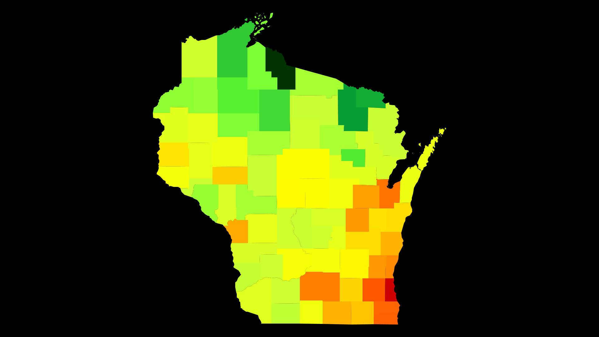
Wisconsin Population Density by County
| County | Population Density (Population/km2) | Population | Area (km2) |
|---|---|---|---|
| Milwaukee County | 1,482 | 956,023 | 645 |
| Waukesha County | 262 | 393,843 | 1,505 |
| Kenosha County | 231 | 167,757 | 725 |
| Racine County | 219 | 195,041 | 890 |
| Brown County | 183 | 254,586 | 1,393 |
| Dane County | 159 | 509,939 | 3,207 |
| Ozaukee County | 141 | 87,054 | 617 |
| Washington County | 118 | 132,739 | 1,129 |
| Winnebago County | 113 | 169,541 | 1,499 |
| Outagamie County | 108 | 180,345 | 1,670 |
| La Crosse County | 94 | 116,713 | 1,243 |
| Sheboygan County | 85 | 114,922 | 1,345 |
| Rock County | 85 | 160,739 | 1,886 |
| Walworth County | 69 | 102,945 | 1,494 |
| Eau Claire County | 61 | 101,438 | 1,671 |
| Jefferson County | 56 | 84,509 | 1,504 |
| Manitowoc County | 52 | 80,654 | 1,555 |
| Fond du Lac County | 51 | 101,798 | 1,985 |
| Calumet County | 48 | 49,617 | 1,027 |
| Saint Croix County | 46 | 87,513 | 1,908 |
| Dodge County | 38 | 88,344 | 2,346 |
| Wood County | 35 | 73,959 | 2,096 |
| Marathon County | 33 | 135,416 | 4,082 |
| Portage County | 33 | 70,380 | 2,131 |
| Sauk County | 29 | 63,162 | 2,198 |
| Columbia County | 27 | 56,653 | 2,067 |
| Pierce County | 27 | 40,976 | 1,532 |
| Waupaca County | 26 | 52,285 | 1,983 |
| Green County | 24 | 37,090 | 1,514 |
| Chippewa County | 23 | 63,132 | 2,699 |
| Kewaunee County | 23 | 20,505 | 897 |
| Door County | 22 | 27,896 | 1,287 |
| Barron County | 20 | 45,676 | 2,304 |
| Dunn County | 20 | 44,122 | 2,237 |
| Green Lake County | 19 | 18,959 | 985 |
| Monroe County | 19 | 45,298 | 2,355 |
| Shawano County | 18 | 41,643 | 2,356 |
| Polk County | 18 | 43,476 | 2,479 |
| Grant County | 17 | 51,069 | 3,060 |
| Trempealeau County | 15 | 29,582 | 1,928 |
| Waushara County | 15 | 24,329 | 1,652 |
| Vernon County | 14 | 30,329 | 2,112 |
| Oconto County | 14 | 37,318 | 2,643 |
| Juneau County | 13 | 26,547 | 2,087 |
| Marquette County | 13 | 15,176 | 1,202 |
| Douglas County | 13 | 43,887 | 3,479 |
| Lincoln County | 12 | 28,684 | 2,349 |
| Iowa County | 12 | 23,749 | 1,991 |
| Richland County | 12 | 17,717 | 1,526 |
| Adams County | 12 | 20,480 | 1,780 |
| Pepin County | 11 | 7,360 | 644 |
| Marinette County | 11 | 41,610 | 3,709 |
| Oneida County | 11 | 35,689 | 3,203 |
| Clark County | 11 | 34,615 | 3,158 |
| Crawford County | 11 | 16,397 | 1,555 |
| Lafayette County | 10 | 16,766 | 1,648 |
| Langlade County | 8.5 | 19,575 | 2,300 |
| Vilas County | 8.1 | 21,368 | 2,638 |
| Taylor County | 8.1 | 20,610 | 2,550 |
| Jackson County | 8.0 | 20,644 | 2,592 |
| Buffalo County | 7.3 | 13,357 | 1,834 |
| Washburn County | 7.1 | 15,686 | 2,209 |
| Burnett County | 6.7 | 15,333 | 2,280 |
| Rusk County | 6.0 | 14,395 | 2,411 |
| Ashland County | 5.9 | 16,016 | 2,734 |
| Sawyer County | 4.7 | 16,513 | 3,495 |
| Menominee County | 4.6 | 4,317 | 945 |
| Price County | 4.2 | 13,802 | 3,312 |
| Bayfield County | 3.9 | 15,156 | 3,918 |
| Florence County | 3.5 | 4,520 | 1,288 |
| Forest County | 3.4 | 9,126 | 2,709 |
| Iron County | 2.8 | 5,886 | 2,079 |
Comments
© 2018 AtlasBig.com