Colorado Population Density
Colorado Population Density Map
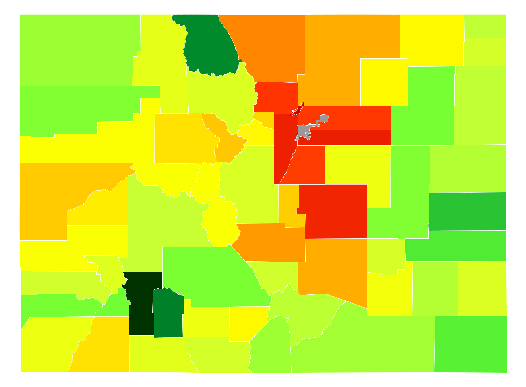
Colorado Population Density by County
| County | Population Density (Population/km2) | Population | Area (km2) |
|---|---|---|---|
| City and County of Broomfield | 756 | 65,065 | 86 |
| Arapahoe County | 292 | 607,070 | 2,080 |
| Jefferson County | 276 | 551,798 | 2,002 |
| Boulder County | 161 | 310,048 | 1,931 |
| Adams County | 152 | 469,193 | 3,082 |
| Douglas County | 141 | 305,963 | 2,175 |
| El Paso County | 119 | 655,044 | 5,516 |
| Larimer County | 46 | 315,988 | 6,831 |
| Weld County | 26 | 269,785 | 10,394 |
| Pueblo County | 26 | 161,451 | 6,233 |
| Summit County | 18 | 28,649 | 1,605 |
| Mesa County | 17 | 147,554 | 8,663 |
| Teller County | 16 | 23,275 | 1,451 |
| Gilpin County | 14 | 5,601 | 396 |
| La Plata County | 12 | 53,284 | 4,397 |
| Eagle County | 12 | 52,460 | 4,382 |
| Fremont County | 12 | 46,451 | 3,967 |
| Delta County | 10 | 30,483 | 2,972 |
| Clear Creek County | 8.7 | 9,031 | 1,033 |
| Alamosa County | 8.7 | 16,253 | 1,879 |
| Morgan County | 8.5 | 28,404 | 3,357 |
| Garfield County | 7.4 | 57,302 | 7,692 |
| Lake County | 7.4 | 7,306 | 993 |
| Chaffee County | 7.0 | 18,510 | 2,632 |
| Montrose County | 7.0 | 40,713 | 5,834 |
| Pitkin County | 6.9 | 17,379 | 2,515 |
| Otero County | 5.7 | 18,703 | 3,288 |
| Rio Grande County | 5.0 | 11,803 | 2,365 |
| Elbert County | 4.9 | 23,733 | 4,810 |
| Montezuma County | 4.9 | 25,642 | 5,286 |
| Logan County | 4.7 | 22,450 | 4,789 |
| Routt County | 3.8 | 23,513 | 6,132 |
| Archuleta County | 3.5 | 12,194 | 3,490 |
| Ouray County | 3.3 | 4,557 | 1,394 |
| Grand County | 3.0 | 14,289 | 4,843 |
| Prowers County | 2.9 | 12,291 | 4,247 |
| Park County | 2.8 | 16,121 | 5,733 |
| Crowley County | 2.6 | 5,322 | 2,074 |
| Conejos County | 2.5 | 8,277 | 3,335 |
| Phillips County | 2.5 | 4,356 | 1,772 |
| San Miguel County | 2.3 | 7,678 | 3,340 |
| Custer County | 2.2 | 4,285 | 1,926 |
| Gunnison County | 1.8 | 15,507 | 8,437 |
| Yuma County | 1.7 | 10,151 | 6,131 |
| Sedgwick County | 1.7 | 2,360 | 1,427 |
| Huerfano County | 1.6 | 6,519 | 4,129 |
| Kit Carson County | 1.4 | 8,037 | 5,599 |
| Bent County | 1.4 | 5,688 | 4,002 |
| Las Animas County | 1.2 | 14,446 | 12,329 |
| Costilla County | 1.1 | 3,518 | 3,205 |
| Moffat County | 1.1 | 13,103 | 12,314 |
| Rio Blanco County | 0.82 | 6,807 | 8,321 |
| Lincoln County | 0.81 | 5,430 | 6,680 |
| Saguache County | 0.76 | 6,208 | 8,213 |
| Washington County | 0.73 | 4,803 | 6,539 |
| Dolores County | 0.73 | 2,029 | 2,774 |
| San Juan County | 0.69 | 692 | 1,007 |
| Baca County | 0.56 | 3,682 | 6,609 |
| Cheyenne County | 0.41 | 1,890 | 4,617 |
| Jackson County | 0.33 | 1,365 | 4,199 |
| Mineral County | 0.32 | 721 | 2,274 |
| Kiowa County | 0.31 | 1,423 | 4,631 |
| Hinsdale County | 0.28 | 813 | 2,914 |
Comments
© 2018 AtlasBig.com