Kansas Population Density
Kansas Population Density Map
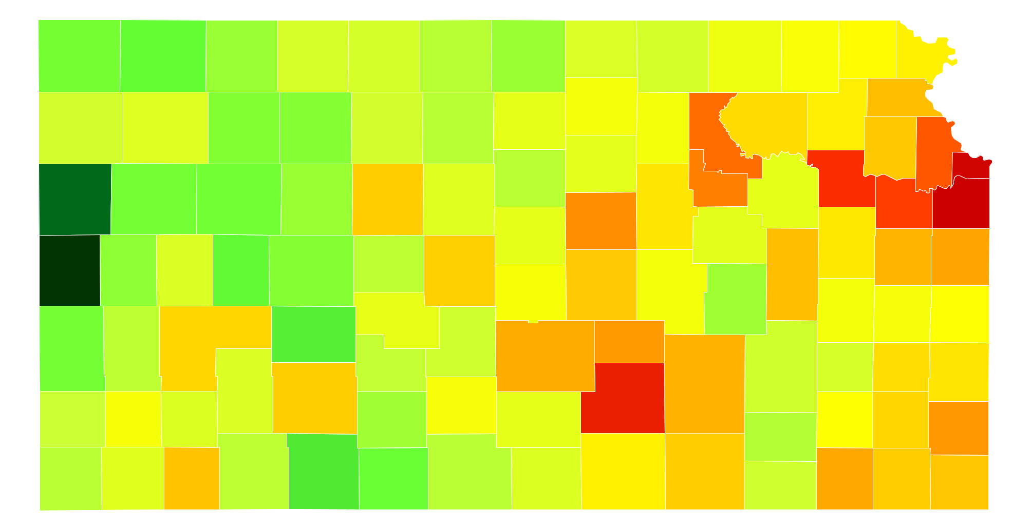
Kansas Population Density by County
| County | Population Density (Population/km2) | Population | Area (km2) |
|---|---|---|---|
| Johnson County | 456 | 566,933 | 1,244 |
| Wyandotte County | 396 | 160,384 | 405 |
| Sedgwick County | 193 | 505,415 | 2,617 |
| Shawnee County | 124 | 178,831 | 1,440 |
| Douglas County | 93 | 114,322 | 1,230 |
| Leavenworth County | 64 | 78,185 | 1,215 |
| Riley County | 47 | 75,394 | 1,612 |
| Geary County | 36 | 37,384 | 1,046 |
| Saline County | 30 | 55,740 | 1,866 |
| Crawford County | 26 | 39,278 | 1,537 |
| Harvey County | 25 | 34,741 | 1,398 |
| Miami County | 21 | 32,835 | 1,528 |
| Montgomery County | 20 | 34,292 | 1,685 |
| Reno County | 19 | 64,190 | 3,294 |
| Butler County | 18 | 65,803 | 3,743 |
| Franklin County | 17 | 25,740 | 1,494 |
| Lyon County | 15 | 33,510 | 2,217 |
| Atchison County | 15 | 16,749 | 1,123 |
| Seward County | 14 | 23,390 | 1,662 |
| Cherokee County | 14 | 20,978 | 1,530 |
| Jefferson County | 13 | 18,813 | 1,442 |
| McPherson County | 13 | 29,569 | 2,340 |
| Ellis County | 12 | 29,061 | 2,337 |
| Cowley County | 12 | 36,204 | 2,926 |
| Labette County | 12 | 20,916 | 1,701 |
| Ford County | 12 | 34,819 | 2,851 |
| Barton County | 12 | 27,509 | 2,326 |
| Finney County | 11 | 37,098 | 3,369 |
| Neosho County | 11 | 16,430 | 1,499 |
| Pottawatomie County | 10 | 22,691 | 2,229 |
| Allen County | 10 | 13,124 | 1,311 |
| Bourbon County | 9.0 | 14,852 | 1,653 |
| Dickinson County | 8.9 | 19,609 | 2,209 |
| Osage County | 8.7 | 16,142 | 1,865 |
| Jackson County | 7.8 | 13,366 | 1,707 |
| Sumner County | 7.7 | 23,591 | 3,074 |
| Doniphan County | 7.6 | 7,851 | 1,032 |
| Brown County | 6.8 | 9,997 | 1,480 |
| Wilson County | 6.1 | 9,105 | 1,486 |
| Linn County | 6.1 | 9,516 | 1,567 |
| Nemaha County | 5.5 | 10,161 | 1,862 |
| Grant County | 5.3 | 7,950 | 1,491 |
| Rice County | 5.3 | 10,011 | 1,889 |
| Anderson County | 5.2 | 7,897 | 1,518 |
| Pratt County | 5.2 | 9,878 | 1,902 |
| Cloud County | 5.0 | 9,292 | 1,856 |
| Coffey County | 5.0 | 8,412 | 1,696 |
| Marion County | 5.0 | 12,219 | 2,465 |
| Clay County | 4.9 | 8,406 | 1,701 |
| Marshall County | 4.3 | 10,002 | 2,348 |
| Pawnee County | 3.6 | 6,971 | 1,945 |
| Kingman County | 3.5 | 7,844 | 2,251 |
| Mitchell County | 3.4 | 6,378 | 1,863 |
| Ellsworth County | 3.4 | 6,398 | 1,875 |
| Wabaunsee County | 3.4 | 7,051 | 2,067 |
| Ottawa County | 3.2 | 6,042 | 1,865 |
| Morris County | 3.2 | 5,741 | 1,817 |
| Stevens County | 3.1 | 5,816 | 1,889 |
| Russell County | 3.0 | 6,933 | 2,329 |
| Thomas County | 2.9 | 7,948 | 2,787 |
| Harper County | 2.8 | 5,860 | 2,088 |
| Haskell County | 2.8 | 4,141 | 1,494 |
| Scott County | 2.7 | 5,035 | 1,876 |
| Gray County | 2.7 | 6,009 | 2,240 |
| Republic County | 2.6 | 4,820 | 1,857 |
| Woodson County | 2.5 | 3,221 | 1,309 |
| Norton County | 2.5 | 5,622 | 2,286 |
| Washington County | 2.4 | 5,629 | 2,325 |
| Phillips County | 2.4 | 5,540 | 2,311 |
| Rooks County | 2.2 | 5,190 | 2,317 |
| Sherman County | 2.2 | 6,115 | 2,737 |
| Greenwood County | 2.2 | 6,424 | 2,987 |
| Stafford County | 2.1 | 4,359 | 2,053 |
| Chautauqua County | 2.1 | 3,552 | 1,679 |
| Edwards County | 1.8 | 2,945 | 1,603 |
| Kearny County | 1.7 | 3,923 | 2,245 |
| Rush County | 1.7 | 3,186 | 1,858 |
| Meade County | 1.7 | 4,343 | 2,545 |
| Lincoln County | 1.7 | 3,147 | 1,867 |
| Barber County | 1.7 | 4,947 | 2,942 |
| Morton County | 1.7 | 3,143 | 1,888 |
| Osborne County | 1.6 | 3,818 | 2,327 |
| Smith County | 1.6 | 3,706 | 2,319 |
| Elk County | 1.6 | 2,655 | 1,685 |
| Kiowa County | 1.3 | 2,523 | 1,870 |
| Chase County | 1.3 | 2,700 | 2,025 |
| Jewell County | 1.3 | 3,046 | 2,382 |
| Trego County | 1.3 | 2,980 | 2,336 |
| Decatur County | 1.3 | 2,930 | 2,314 |
| Stanton County | 1.2 | 2,194 | 1,763 |
| Wichita County | 1.2 | 2,192 | 1,865 |
| Graham County | 1.1 | 2,593 | 2,331 |
| Ness County | 1.1 | 3,073 | 2,784 |
| Sheridan County | 1.1 | 2,553 | 2,320 |
| Cheyenne County | 1.0 | 2,694 | 2,645 |
| Hamilton County | 1.0 | 2,609 | 2,589 |
| Logan County | 1.0 | 2,798 | 2,784 |
| Gove County | 1.0 | 2,769 | 2,764 |
| Comanche County | 0.96 | 1,955 | 2,047 |
| Rawlins County | 0.94 | 2,589 | 2,767 |
| Lane County | 0.92 | 1,720 | 1,862 |
| Hodgeman County | 0.88 | 1,950 | 2,225 |
| Clark County | 0.86 | 2,193 | 2,544 |
| Wallace County | 0.66 | 1,569 | 2,366 |
| Greeley County | 0.64 | 1,290 | 2,009 |
Comments
© 2018 AtlasBig.com