Minnesota Population Density
Minnesota Population Density Map
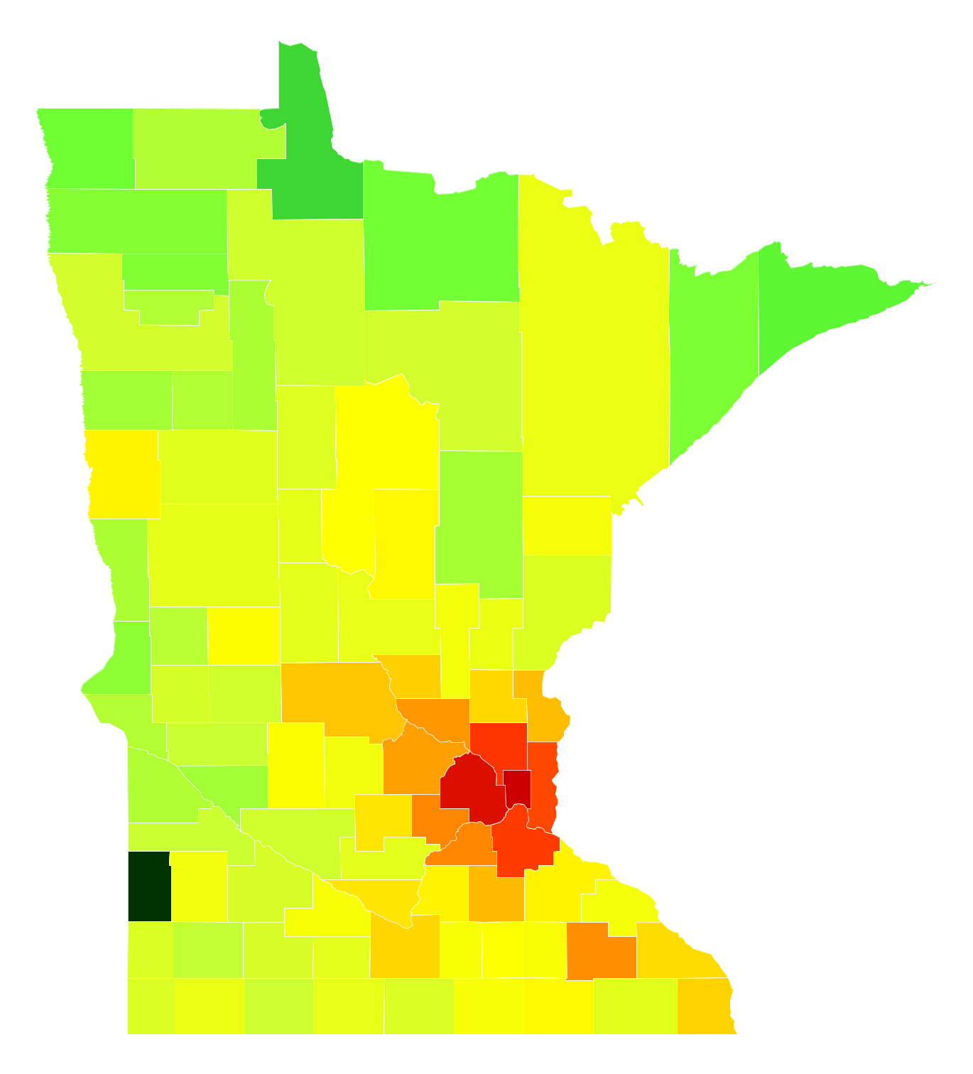
Minnesota Population Density by County
| County | Population Density (Population/km2) | Population | Area (km2) |
|---|---|---|---|
| Ramsey County | 1,195 | 526,714 | 441 |
| Hennepin County | 762 | 1,198,778 | 1,573 |
| Anoka County | 294 | 339,534 | 1,155 |
| Dakota County | 271 | 408,509 | 1,508 |
| Washington County | 225 | 246,603 | 1,098 |
| Scott County | 145 | 137,232 | 949 |
| Carver County | 99 | 95,562 | 970 |
| Olmsted County | 88 | 149,226 | 1,696 |
| Sherburne County | 77 | 90,158 | 1,167 |
| Wright County | 70 | 128,470 | 1,844 |
| Rice County | 49 | 65,049 | 1,339 |
| Chisago County | 47 | 53,761 | 1,144 |
| Stearns County | 42 | 152,092 | 3,603 |
| Benton County | 37 | 39,214 | 1,072 |
| Blue Earth County | 33 | 65,528 | 1,977 |
| Steele County | 33 | 36,465 | 1,111 |
| Isanti County | 32 | 38,204 | 1,178 |
| Winona County | 31 | 51,232 | 1,645 |
| McLeod County | 28 | 35,918 | 1,300 |
| Nicollet County | 27 | 33,032 | 1,216 |
| Goodhue County | 23 | 46,464 | 2,021 |
| Le Sueur County | 23 | 27,810 | 1,226 |
| Clay County | 22 | 60,661 | 2,733 |
| Mower County | 21 | 39,327 | 1,849 |
| Crow Wing County | 21 | 63,208 | 3,002 |
| Douglas County | 20 | 36,545 | 1,862 |
| Kandiyohi County | 19 | 42,410 | 2,233 |
| Dodge County | 18 | 20,349 | 1,139 |
| Waseca County | 17 | 19,098 | 1,125 |
| Freeborn County | 16 | 30,948 | 1,880 |
| Brown County | 16 | 25,332 | 1,592 |
| Carlton County | 16 | 35,460 | 2,261 |
| Wabasha County | 15 | 21,443 | 1,424 |
| Mille Lacs County | 15 | 25,833 | 1,764 |
| Meeker County | 14 | 23,119 | 1,675 |
| Lyon County | 14 | 25,487 | 1,860 |
| Houston County | 13 | 18,799 | 1,487 |
| Kanabec County | 12 | 15,996 | 1,383 |
| Nobles County | 12 | 21,617 | 1,879 |
| Saint Louis County | 11 | 200,431 | 17,492 |
| Morrison County | 11 | 32,872 | 2,976 |
| Martin County | 11 | 20,422 | 1,902 |
| Otter Tail County | 10.0 | 57,581 | 5,787 |
| Wadena County | 9.8 | 13,804 | 1,403 |
| Watonwan County | 9.8 | 11,137 | 1,135 |
| Sibley County | 9.8 | 15,072 | 1,545 |
| Todd County | 9.6 | 24,382 | 2,543 |
| Fillmore County | 9.3 | 20,835 | 2,240 |
| Becker County | 8.9 | 33,231 | 3,724 |
| Pennington County | 8.8 | 14,118 | 1,607 |
| Hubbard County | 8.0 | 20,658 | 2,594 |
| Chippewa County | 7.9 | 12,093 | 1,531 |
| Pine County | 7.9 | 29,104 | 3,701 |
| Pipestone County | 7.6 | 9,270 | 1,212 |
| Rock County | 7.6 | 9,520 | 1,252 |
| Faribault County | 7.5 | 14,191 | 1,883 |
| Cottonwood County | 6.9 | 11,616 | 1,673 |
| Redwood County | 6.9 | 15,744 | 2,286 |
| Stevens County | 6.5 | 9,735 | 1,493 |
| Polk County | 6.1 | 31,569 | 5,172 |
| Itasca County | 6.0 | 45,564 | 7,595 |
| Renville County | 5.9 | 15,166 | 2,566 |
| Pope County | 5.9 | 10,932 | 1,863 |
| Beltrami County | 5.8 | 45,670 | 7,933 |
| Jackson County | 5.5 | 10,260 | 1,872 |
| Yellow Medicine County | 5.1 | 10,143 | 1,979 |
| Swift County | 4.9 | 9,546 | 1,941 |
| Murray County | 4.6 | 8,533 | 1,862 |
| Cass County | 4.6 | 28,555 | 6,246 |
| Lincoln County | 4.1 | 5,830 | 1,426 |
| Grant County | 4.0 | 5,989 | 1,486 |
| Big Stone County | 3.7 | 5,122 | 1,369 |
| Red Lake County | 3.6 | 4,057 | 1,121 |
| Mahnomen County | 3.6 | 5,532 | 1,529 |
| Roseau County | 3.6 | 15,520 | 4,338 |
| Lac qui Parle County | 3.5 | 7,027 | 2,015 |
| Wilkin County | 3.4 | 6,557 | 1,938 |
| Clearwater County | 3.3 | 8,838 | 2,663 |
| Aitkin County | 3.0 | 15,742 | 5,190 |
| Norman County | 2.9 | 6,631 | 2,271 |
| Traverse County | 2.3 | 3,445 | 1,517 |
| Marshall County | 2.0 | 9,425 | 4,685 |
| Lake County | 1.8 | 10,777 | 5,934 |
| Koochiching County | 1.6 | 13,206 | 8,159 |
| Kittson County | 1.6 | 4,503 | 2,852 |
| Cook County | 1.2 | 5,200 | 4,172 |
| Lake of the Woods County | 0.85 | 3,929 | 4,595 |
Comments
© 2018 AtlasBig.com