Missouri Population Density
Missouri Population Density Map
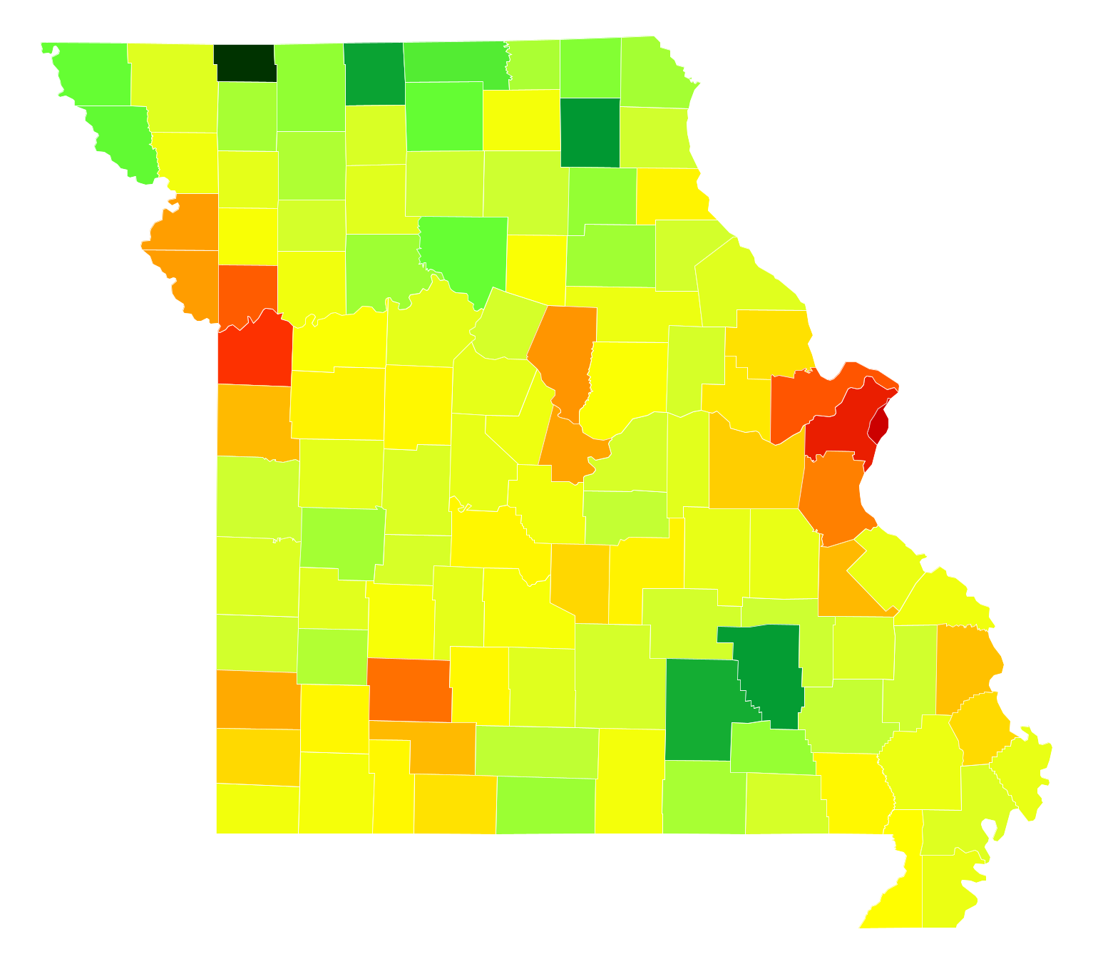
Missouri Population Density by County
| County | Population Density (Population/km2) | Population | Area (km2) |
|---|---|---|---|
| City of St. Louis | 1,850 | 315,685 | 171 |
| St. Louis County | 739 | 1,001,444 | 1,355 |
| Jackson County | 430 | 679,996 | 1,583 |
| St. Charles County | 244 | 373,495 | 1,532 |
| Clay County | 218 | 230,473 | 1,055 |
| Greene County | 162 | 283,870 | 1,756 |
| Jefferson County | 129 | 221,396 | 1,716 |
| Boone County | 95 | 170,773 | 1,792 |
| Platte County | 84 | 93,310 | 1,106 |
| Buchanan County | 83 | 89,631 | 1,074 |
| Cole County | 75 | 76,699 | 1,017 |
| Jasper County | 70 | 116,398 | 1,658 |
| St. Francois County | 56 | 66,215 | 1,175 |
| Cass County | 55 | 100,641 | 1,815 |
| Christian County | 55 | 80,899 | 1,462 |
| Cape Girardeau County | 51 | 77,320 | 1,523 |
| Franklin County | 42 | 101,816 | 2,416 |
| Pulaski County | 37 | 53,748 | 1,444 |
| Newton County | 36 | 58,845 | 1,626 |
| Scott County | 35 | 39,290 | 1,107 |
| Lincoln County | 32 | 53,860 | 1,663 |
| Taney County | 32 | 53,575 | 1,688 |
| Warren County | 29 | 32,999 | 1,136 |
| Phelps County | 25 | 44,807 | 1,767 |
| Johnson County | 25 | 54,572 | 2,159 |
| Marion County | 25 | 28,904 | 1,151 |
| Lawrence County | 24 | 38,185 | 1,586 |
| Camden County | 24 | 43,862 | 1,830 |
| Pettis County | 24 | 42,205 | 1,770 |
| Butler County | 24 | 43,083 | 1,815 |
| Stone County | 24 | 31,297 | 1,322 |
| Webster County | 24 | 36,466 | 1,543 |
| Dunklin County | 22 | 31,712 | 1,414 |
| Callaway County | 20 | 44,359 | 2,205 |
| Lafayette County | 20 | 32,943 | 1,651 |
| Randolph County | 20 | 24,940 | 1,271 |
| Clinton County | 19 | 20,571 | 1,081 |
| Polk County | 18 | 30,974 | 1,675 |
| Laclede County | 18 | 35,667 | 1,988 |
| Barry County | 17 | 35,572 | 2,053 |
| Adair County | 17 | 25,572 | 1,477 |
| Howell County | 17 | 40,393 | 2,410 |
| McDonald County | 16 | 22,558 | 1,396 |
| Miller County | 16 | 25,092 | 1,564 |
| Ray County | 16 | 23,039 | 1,480 |
| Andrew County | 15 | 17,445 | 1,128 |
| Perry County | 15 | 19,072 | 1,252 |
| Moniteau County | 14 | 15,748 | 1,088 |
| Audrain County | 14 | 25,661 | 1,806 |
| Stoddard County | 14 | 29,780 | 2,152 |
| Pemiscot County | 14 | 17,823 | 1,315 |
| Sainte Genevieve County | 13 | 17,919 | 1,328 |
| Mississippi County | 13 | 14,282 | 1,110 |
| Washington County | 13 | 25,172 | 1,975 |
| Crawford County | 13 | 24,543 | 1,933 |
| Morgan County | 13 | 20,265 | 1,606 |
| Cooper County | 12 | 17,647 | 1,477 |
| Saline County | 12 | 23,252 | 1,978 |
| DeKalb County | 12 | 12,840 | 1,095 |
| Dallas County | 12 | 16,535 | 1,417 |
| Henry County | 12 | 22,059 | 1,898 |
| Gasconade County | 11 | 14,901 | 1,346 |
| Cedar County | 11 | 13,913 | 1,290 |
| Livingston County | 11 | 14,871 | 1,396 |
| Wright County | 10 | 18,473 | 1,760 |
| Pike County | 10 | 18,669 | 1,779 |
| Nodaway County | 10 | 23,261 | 2,266 |
| New Madrid County | 10 | 18,365 | 1,813 |
| Benton County | 9.7 | 18,932 | 1,945 |
| Vernon County | 9.7 | 20,949 | 2,169 |
| Madison County | 9.6 | 12,431 | 1,289 |
| Grundy County | 9.1 | 10,355 | 1,132 |
| Hickory County | 8.7 | 9,305 | 1,064 |
| Osage County | 8.7 | 13,688 | 1,569 |
| Montgomery County | 8.6 | 11,965 | 1,394 |
| Ripley County | 8.6 | 14,032 | 1,636 |
| Howard County | 8.5 | 10,257 | 1,212 |
| Texas County | 8.4 | 25,636 | 3,058 |
| Caldwell County | 8.2 | 9,097 | 1,115 |
| Ralls County | 8.1 | 10,192 | 1,257 |
| Dent County | 8.1 | 15,730 | 1,954 |
| Barton County | 8.0 | 12,275 | 1,534 |
| Bollinger County | 7.8 | 12,490 | 1,598 |
| Lewis County | 7.7 | 10,152 | 1,317 |
| Linn County | 7.7 | 12,368 | 1,615 |
| Bates County | 7.5 | 16,550 | 2,207 |
| Macon County | 7.4 | 15,544 | 2,098 |
| Iron County | 7.2 | 10,344 | 1,429 |
| Wayne County | 6.7 | 13,404 | 2,009 |
| Maries County | 6.6 | 9,018 | 1,374 |
| Douglas County | 6.3 | 13,515 | 2,129 |
| Dade County | 5.7 | 7,578 | 1,324 |
| Daviess County | 5.6 | 8,294 | 1,474 |
| Schuyler County | 5.5 | 4,358 | 799 |
| Oregon County | 5.4 | 10,996 | 2,051 |
| Gentry County | 5.3 | 6,775 | 1,280 |
| St. Clair County | 5.2 | 9,487 | 1,820 |
| Clark County | 5.2 | 6,910 | 1,328 |
| Monroe County | 5.1 | 8,774 | 1,733 |
| Carroll County | 5.0 | 9,127 | 1,819 |
| Ozark County | 4.9 | 9,560 | 1,945 |
| Carter County | 4.8 | 6,291 | 1,320 |
| Shelby County | 4.7 | 6,177 | 1,305 |
| Harrison County | 4.6 | 8,741 | 1,883 |
| Scotland County | 4.3 | 4,921 | 1,139 |
| Chariton County | 3.8 | 7,628 | 1,994 |
| Atchison County | 3.8 | 5,449 | 1,429 |
| Sullivan County | 3.8 | 6,448 | 1,696 |
| Holt County | 3.8 | 4,568 | 1,211 |
| Putnam County | 3.6 | 4,875 | 1,353 |
| Shannon County | 3.2 | 8,297 | 2,598 |
| Mercer County | 3.2 | 3,695 | 1,170 |
| Reynolds County | 3.1 | 6,599 | 2,103 |
| Knox County | 3.1 | 4,067 | 1,303 |
| Worth County | 3.0 | 2,090 | 703 |
Comments
© 2018 AtlasBig.com