Nebraska Population Density
Nebraska Population Density Map
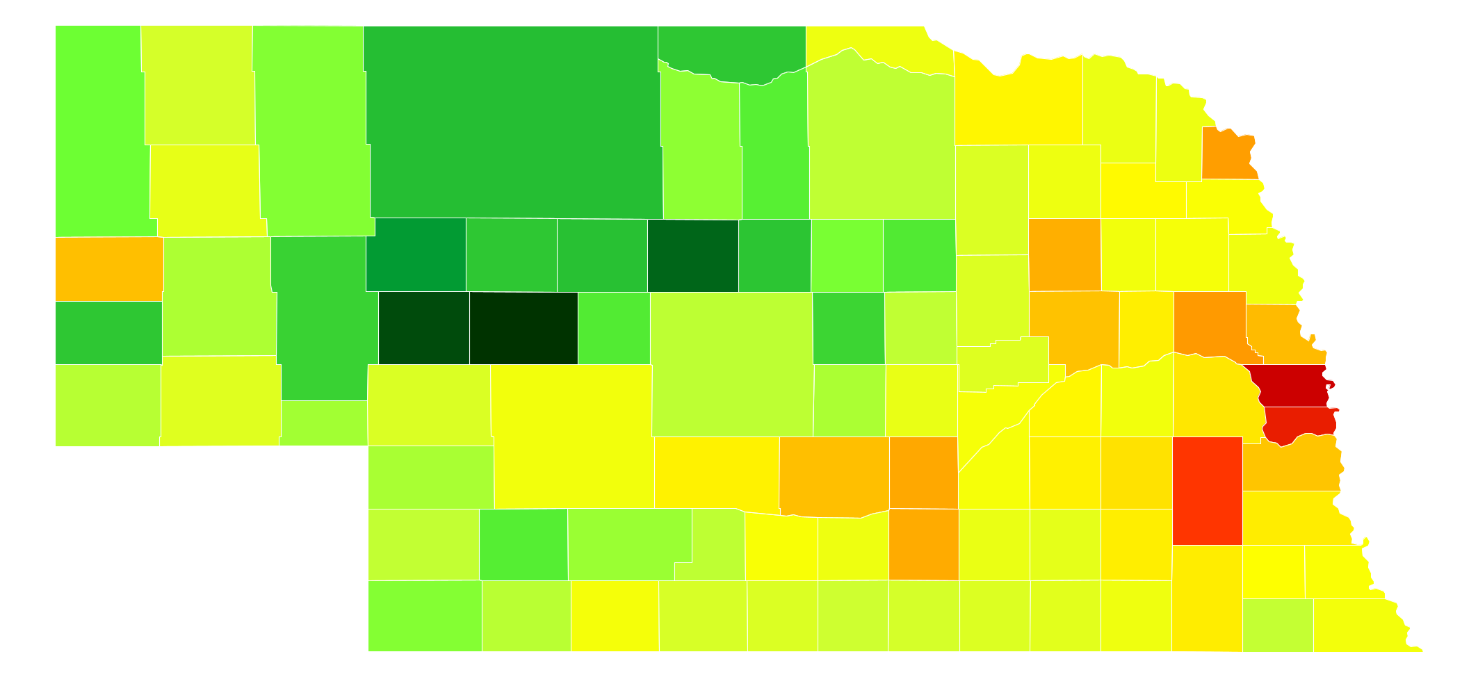
Nebraska Population Density by County
| County | Population Density (Population/km2) | Population | Area (km2) |
|---|---|---|---|
| Douglas County | 611 | 537,256 | 879 |
| Sarpy County | 264 | 169,331 | 642 |
| Lancaster County | 135 | 297,036 | 2,196 |
| Hall County | 42 | 60,720 | 1,431 |
| Dakota County | 30 | 20,947 | 692 |
| Dodge County | 26 | 36,515 | 1,417 |
| Madison County | 24 | 35,278 | 1,482 |
| Adams County | 22 | 31,610 | 1,460 |
| Washington County | 20 | 20,223 | 1,016 |
| Scotts Bluff County | 19 | 36,848 | 1,941 |
| Buffalo County | 19 | 47,893 | 2,523 |
| Platte County | 18 | 32,505 | 1,799 |
| Cass County | 17 | 25,357 | 1,467 |
| Seward County | 11 | 17,089 | 1,493 |
| Saunders County | 11 | 20,929 | 1,960 |
| Otoe County | 9.8 | 15,752 | 1,605 |
| Gage County | 9.8 | 21,864 | 2,230 |
| Saline County | 9.7 | 14,416 | 1,490 |
| Colfax County | 9.6 | 10,425 | 1,091 |
| York County | 9.3 | 13,883 | 1,497 |
| Dawson County | 9.2 | 24,207 | 2,644 |
| Wayne County | 8.2 | 9,411 | 1,151 |
| Thurston County | 6.8 | 6,895 | 1,018 |
| Nemaha County | 6.7 | 7,157 | 1,063 |
| Phelps County | 6.6 | 9,213 | 1,399 |
| Hamilton County | 6.4 | 9,112 | 1,415 |
| Merrick County | 6.1 | 7,802 | 1,280 |
| Cuming County | 6.0 | 8,996 | 1,490 |
| Red Willow County | 5.9 | 11,006 | 1,854 |
| Richardson County | 5.7 | 8,125 | 1,434 |
| Stanton County | 5.5 | 6,133 | 1,114 |
| Butler County | 5.5 | 8,312 | 1,513 |
| Lincoln County | 5.4 | 36,051 | 6,674 |
| Johnson County | 5.3 | 5,144 | 974 |
| Burt County | 5.1 | 6,574 | 1,291 |
| Jefferson County | 5.1 | 7,560 | 1,490 |
| Kearney County | 4.9 | 6,548 | 1,333 |
| Pierce County | 4.8 | 7,150 | 1,485 |
| Dixon County | 4.7 | 5,851 | 1,245 |
| Polk County | 4.6 | 5,275 | 1,138 |
| Cedar County | 4.5 | 8,711 | 1,921 |
| Clay County | 4.3 | 6,392 | 1,484 |
| Howard County | 4.3 | 6,355 | 1,483 |
| Box Butte County | 4.1 | 11,305 | 2,789 |
| Fillmore County | 3.8 | 5,698 | 1,495 |
| Thayer County | 3.5 | 5,189 | 1,492 |
| Cheyenne County | 3.3 | 10,091 | 3,097 |
| Nance County | 3.1 | 3,623 | 1,161 |
| Boone County | 3.0 | 5,388 | 1,792 |
| Nuckolls County | 3.0 | 4,413 | 1,495 |
| Knox County | 2.9 | 8,565 | 2,944 |
| Antelope County | 2.9 | 6,456 | 2,225 |
| Keith County | 2.8 | 8,130 | 2,875 |
| Valley County | 2.8 | 4,193 | 1,483 |
| Furnas County | 2.6 | 4,865 | 1,863 |
| Dawes County | 2.5 | 9,088 | 3,626 |
| Webster County | 2.5 | 3,688 | 1,501 |
| Pawnee County | 2.4 | 2,709 | 1,121 |
| Harlan County | 2.4 | 3,513 | 1,481 |
| Sherman County | 2.1 | 3,106 | 1,475 |
| Franklin County | 2.1 | 3,085 | 1,492 |
| Chase County | 1.7 | 4,000 | 2,329 |
| Deuel County | 1.7 | 1,937 | 1,139 |
| Greeley County | 1.7 | 2,494 | 1,480 |
| Holt County | 1.7 | 10,449 | 6,267 |
| Gosper County | 1.6 | 1,972 | 1,199 |
| Custer County | 1.6 | 10,792 | 6,672 |
| Hitchcock County | 1.5 | 2,872 | 1,866 |
| Kimball County | 1.5 | 3,702 | 2,463 |
| Boyd County | 1.4 | 2,032 | 1,404 |
| Garfield County | 1.4 | 2,035 | 1,473 |
| Morrill County | 1.3 | 4,908 | 3,714 |
| Perkins County | 1.3 | 2,921 | 2,302 |
| Frontier County | 1.1 | 2,709 | 2,539 |
| Brown County | 0.92 | 2,926 | 3,169 |
| Dundy County | 0.83 | 1,981 | 2,388 |
| Sheridan County | 0.82 | 5,251 | 6,406 |
| Rock County | 0.54 | 1,411 | 2,633 |
| Hayes County | 0.53 | 976 | 1,847 |
| Logan County | 0.52 | 763 | 1,478 |
| Wheeler County | 0.51 | 759 | 1,487 |
| Garden County | 0.42 | 1,902 | 4,478 |
| Hooker County | 0.39 | 738 | 1,871 |
| Banner County | 0.39 | 759 | 1,928 |
| Keya Paha County | 0.39 | 790 | 2,008 |
| Loup County | 0.39 | 576 | 1,479 |
| Thomas County | 0.38 | 699 | 1,842 |
| Cherry County | 0.37 | 5,788 | 15,557 |
| Grant County | 0.31 | 633 | 2,036 |
| Blaine County | 0.26 | 482 | 1,859 |
| Sioux County | 0.25 | 1,313 | 5,357 |
| Arthur County | 0.25 | 458 | 1,869 |
| McPherson County | 0.24 | 526 | 2,226 |
Comments
© 2018 AtlasBig.com