Ohio Population Density
Ohio Population Density Map
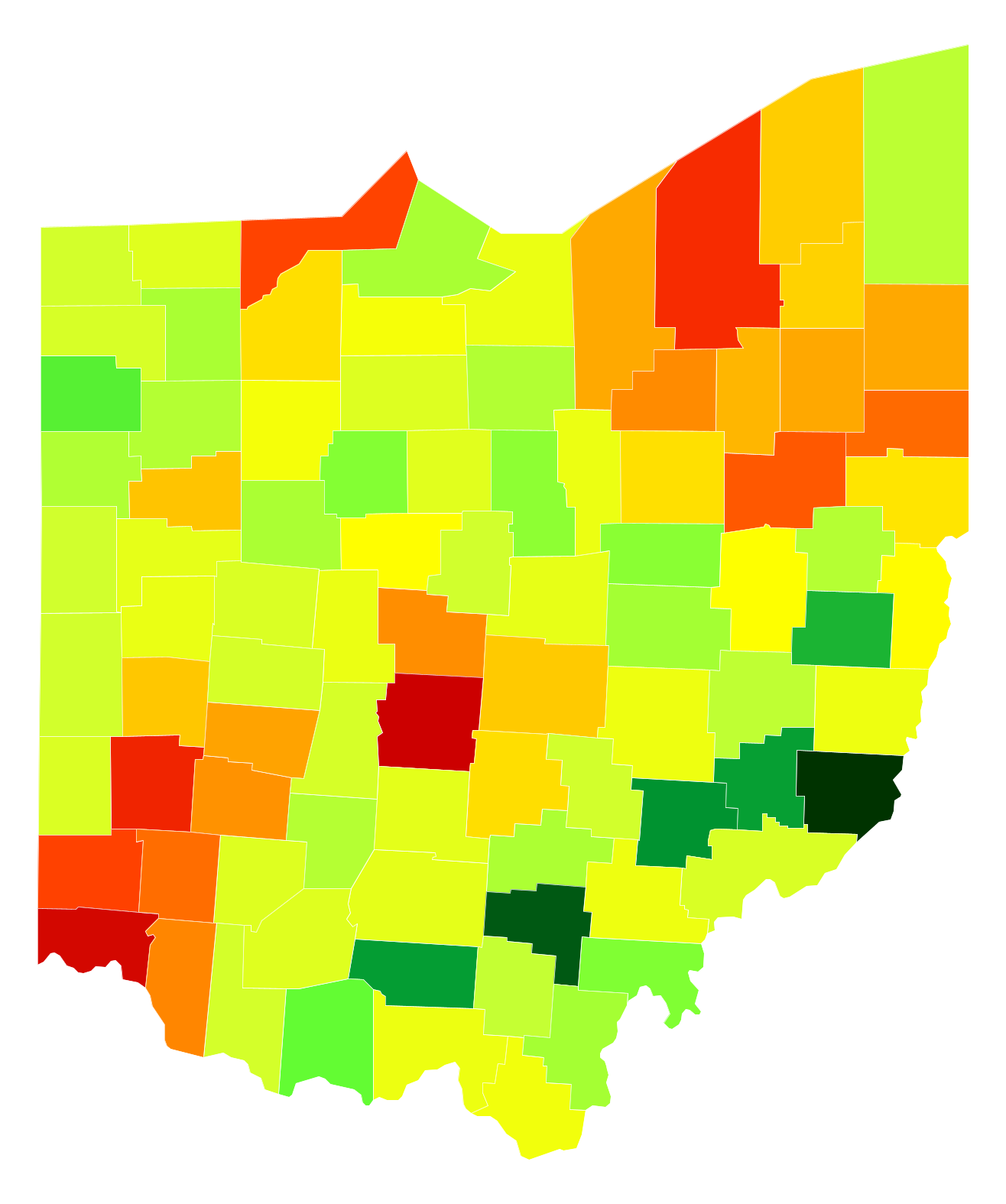
Ohio Population Density by County
| County | Population Density (Population/km2) | Population | Area (km2) |
|---|---|---|---|
| Franklin County | 861 | 1,212,263 | 1,409 |
| Hamilton County | 752 | 804,520 | 1,069 |
| Summit County | 498 | 541,824 | 1,088 |
| Montgomery County | 445 | 535,846 | 1,204 |
| Cuyahoga County | 392 | 1,263,154 | 3,221 |
| Butler County | 305 | 371,272 | 1,217 |
| Lucas County | 299 | 436,393 | 1,459 |
| Stark County | 250 | 375,432 | 1,503 |
| Mahoning County | 212 | 233,869 | 1,101 |
| Warren County | 208 | 219,169 | 1,054 |
| Clermont County | 168 | 200,218 | 1,192 |
| Medina County | 160 | 174,915 | 1,095 |
| Delaware County | 156 | 184,979 | 1,185 |
| Greene County | 151 | 163,204 | 1,078 |
| Clark County | 131 | 136,167 | 1,040 |
| Portage County | 125 | 163,862 | 1,306 |
| Trumbull County | 125 | 206,442 | 1,646 |
| Lorain County | 124 | 302,827 | 2,440 |
| Fairfield County | 113 | 148,867 | 1,317 |
| Allen County | 100 | 105,298 | 1,055 |
| Miami County | 98 | 103,439 | 1,061 |
| Licking County | 95 | 168,375 | 1,781 |
| Richland County | 94 | 121,773 | 1,296 |
| Lake County | 92 | 229,857 | 2,489 |
| Geauga County | 89 | 93,972 | 1,058 |
| Wood County | 80 | 129,264 | 1,607 |
| Wayne County | 80 | 115,071 | 1,443 |
| Columbiana County | 76 | 105,893 | 1,385 |
| Jefferson County | 64 | 67,964 | 1,062 |
| Marion County | 63 | 65,905 | 1,047 |
| Tuscarawas County | 63 | 92,672 | 1,479 |
| Sandusky County | 56 | 60,098 | 1,081 |
| Hancock County | 55 | 75,773 | 1,382 |
| Lawrence County | 52 | 61,917 | 1,183 |
| Belmont County | 50 | 69,571 | 1,404 |
| Athens County | 49 | 64,681 | 1,316 |
| Muskingum County | 49 | 85,231 | 1,741 |
| Scioto County | 49 | 78,153 | 1,599 |
| Ashland County | 48 | 53,043 | 1,105 |
| Union County | 47 | 53,306 | 1,132 |
| Erie County | 47 | 76,048 | 1,618 |
| Shelby County | 46 | 49,192 | 1,063 |
| Huron County | 46 | 58,889 | 1,285 |
| Knox County | 44 | 60,810 | 1,372 |
| Auglaize County | 44 | 45,920 | 1,041 |
| Ross County | 43 | 77,910 | 1,795 |
| Pickaway County | 43 | 56,304 | 1,312 |
| Crawford County | 41 | 42,808 | 1,043 |
| Fulton County | 40 | 42,488 | 1,054 |
| Holmes County | 40 | 43,593 | 1,100 |
| Clinton County | 39 | 41,945 | 1,069 |
| Seneca County | 39 | 55,914 | 1,432 |
| Preble County | 38 | 41,732 | 1,105 |
| Logan County | 38 | 45,481 | 1,209 |
| Washington County | 37 | 61,310 | 1,656 |
| Defiance County | 36 | 38,532 | 1,072 |
| Madison County | 36 | 43,277 | 1,211 |
| Champaign County | 35 | 39,455 | 1,114 |
| Brown County | 35 | 44,264 | 1,278 |
| Williams County | 34 | 37,500 | 1,095 |
| Perry County | 34 | 35,997 | 1,069 |
| Darke County | 34 | 52,376 | 1,556 |
| Mercer County | 33 | 40,784 | 1,226 |
| Morrow County | 33 | 35,033 | 1,055 |
| Jackson County | 30 | 32,783 | 1,092 |
| Highland County | 30 | 43,299 | 1,444 |
| Guernsey County | 29 | 39,636 | 1,369 |
| Ashtabula County | 29 | 99,811 | 3,501 |
| Carroll County | 27 | 28,275 | 1,034 |
| Fayette County | 27 | 28,800 | 1,055 |
| Putnam County | 27 | 34,088 | 1,254 |
| Van Wert County | 27 | 28,459 | 1,062 |
| Hocking County | 26 | 28,665 | 1,097 |
| Hardin County | 26 | 31,641 | 1,219 |
| Henry County | 26 | 28,092 | 1,089 |
| Ottawa County | 26 | 41,153 | 1,602 |
| Gallia County | 25 | 30,621 | 1,220 |
| Coshocton County | 25 | 36,760 | 1,470 |
| Pike County | 25 | 28,367 | 1,149 |
| Wyandot County | 21 | 22,447 | 1,055 |
| Meigs County | 21 | 23,496 | 1,121 |
| Adams County | 18 | 28,105 | 1,520 |
| Paulding County | 18 | 19,254 | 1,087 |
| Harrison County | 15 | 15,622 | 1,064 |
| Noble County | 14 | 14,628 | 1,048 |
| Morgan County | 14 | 14,904 | 1,094 |
| Vinton County | 12 | 13,276 | 1,074 |
| Monroe County | 12 | 14,585 | 1,184 |
Comments
© 2018 AtlasBig.com