Oklahoma Population Density
Oklahoma Population Density Map
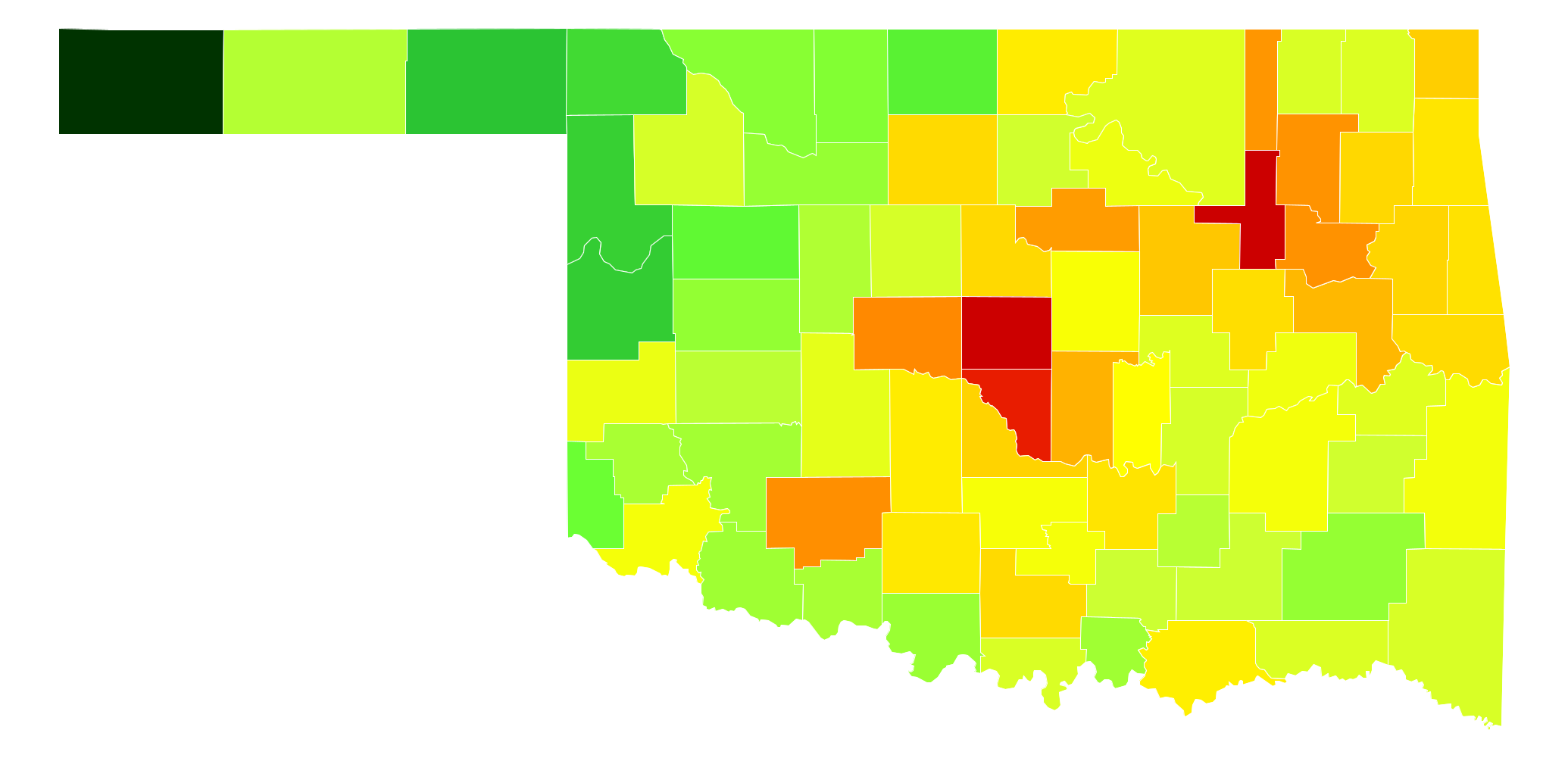
Oklahoma Population Density by County
| County | Population Density (Population/km2) | Population | Area (km2) |
|---|---|---|---|
| Tulsa County | 413 | 622,409 | 1,506 |
| Oklahoma County | 406 | 755,245 | 1,861 |
| Cleveland County | 187 | 269,340 | 1,442 |
| Canadian County | 54 | 126,123 | 2,337 |
| Wagoner County | 49 | 75,700 | 1,547 |
| Rogers County | 48 | 89,044 | 1,843 |
| Washington County | 47 | 51,577 | 1,091 |
| Comanche County | 45 | 124,937 | 2,798 |
| Payne County | 44 | 79,066 | 1,793 |
| Pottawatomie County | 35 | 71,158 | 2,045 |
| Muskogee County | 32 | 70,303 | 2,170 |
| Creek County | 28 | 70,470 | 2,536 |
| Ottawa County | 26 | 32,245 | 1,258 |
| McClain County | 24 | 36,511 | 1,500 |
| Cherokee County | 24 | 48,017 | 2,015 |
| Mayes County | 23 | 40,804 | 1,776 |
| Logan County | 23 | 44,422 | 1,941 |
| Garfield County | 23 | 62,267 | 2,741 |
| Carter County | 23 | 48,491 | 2,150 |
| Sequoyah County | 22 | 41,218 | 1,855 |
| Okmulgee County | 22 | 39,438 | 1,831 |
| Pontotoc County | 20 | 37,992 | 1,875 |
| Delaware County | 20 | 41,377 | 2,059 |
| Stephens County | 19 | 44,919 | 2,308 |
| Grady County | 19 | 53,685 | 2,865 |
| Kay County | 19 | 45,633 | 2,446 |
| Bryan County | 18 | 44,244 | 2,454 |
| Seminole County | 15 | 25,426 | 1,662 |
| Adair County | 15 | 22,194 | 1,495 |
| Marshall County | 15 | 15,988 | 1,097 |
| Lincoln County | 14 | 34,351 | 2,499 |
| Garvin County | 13 | 27,334 | 2,107 |
| Pittsburg County | 12 | 44,703 | 3,578 |
| Murray County | 12 | 13,712 | 1,099 |
| Jackson County | 12 | 26,088 | 2,091 |
| Le Flore County | 12 | 49,774 | 4,178 |
| Custer County | 11 | 29,377 | 2,589 |
| McIntosh County | 11 | 20,493 | 1,837 |
| Pawnee County | 11 | 16,513 | 1,543 |
| Beckham County | 10 | 23,637 | 2,347 |
| Caddo County | 8.9 | 29,594 | 3,313 |
| Haskell County | 8.1 | 13,052 | 1,617 |
| Osage County | 8.0 | 47,987 | 5,983 |
| Okfuskee County | 7.6 | 12,377 | 1,619 |
| Craig County | 7.5 | 14,672 | 1,963 |
| Choctaw County | 7.3 | 15,045 | 2,069 |
| Love County | 7.0 | 9,742 | 1,388 |
| Nowata County | 7.0 | 10,555 | 1,505 |
| McCurtain County | 6.8 | 33,065 | 4,898 |
| Woodward County | 6.6 | 21,221 | 3,229 |
| Hughes County | 6.6 | 13,823 | 2,108 |
| Kingfisher County | 6.5 | 15,276 | 2,357 |
| Johnston County | 6.4 | 10,990 | 1,707 |
| Noble County | 6.0 | 11,446 | 1,922 |
| Latimer County | 5.7 | 10,775 | 1,880 |
| Atoka County | 5.4 | 13,898 | 2,555 |
| Washita County | 4.5 | 11,678 | 2,615 |
| Coal County | 4.3 | 5,867 | 1,353 |
| Texas County | 4.2 | 22,081 | 5,305 |
| Blaine County | 4.0 | 9,720 | 2,417 |
| Greer County | 3.7 | 6,171 | 1,661 |
| Cotton County | 3.7 | 6,152 | 1,668 |
| Kiowa County | 3.5 | 9,341 | 2,673 |
| Tillman County | 3.4 | 7,711 | 2,283 |
| Jefferson County | 3.2 | 6,432 | 2,014 |
| Major County | 3.1 | 7,683 | 2,478 |
| Pushmataha County | 3.1 | 11,233 | 3,677 |
| Woods County | 2.7 | 9,041 | 3,340 |
| Alfalfa County | 2.6 | 5,847 | 2,286 |
| Harmon County | 2.1 | 2,869 | 1,392 |
| Dewey County | 1.9 | 4,844 | 2,615 |
| Grant County | 1.7 | 4,528 | 2,598 |
| Harper County | 1.4 | 3,813 | 2,701 |
| Ellis County | 1.3 | 4,170 | 3,197 |
| Roger Mills County | 1.3 | 3,743 | 2,977 |
| Beaver County | 1.2 | 5,566 | 4,704 |
| Cimarron County | 0.49 | 2,335 | 4,771 |
Comments
© 2018 AtlasBig.com