West Virginia Population Density
West Virginia Population Density Map
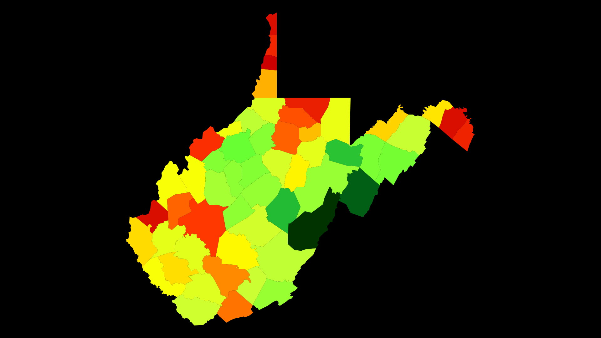
West Virginia Population Density by County
| County | Population Density (Population/km2) | Population | Area (km2) |
|---|---|---|---|
| Ohio County | 155 | 43,727 | 283 |
| Hancock County | 132 | 30,291 | 229 |
| Cabell County | 131 | 97,133 | 739 |
| Berkeley County | 130 | 108,706 | 833 |
| Monongalia County | 107 | 102,274 | 953 |
| Jefferson County | 101 | 55,073 | 547 |
| Brooke County | 99 | 23,737 | 241 |
| Wood County | 88 | 86,569 | 980 |
| Kanawha County | 81 | 191,275 | 2,349 |
| Marion County | 70 | 56,868 | 807 |
| Harrison County | 64 | 68,972 | 1,083 |
| Putnam County | 62 | 56,650 | 906 |
| Mercer County | 57 | 61,984 | 1,086 |
| Raleigh County | 50 | 78,833 | 1,577 |
| Marshall County | 40 | 32,459 | 810 |
| Taylor County | 37 | 16,973 | 458 |
| Mineral County | 33 | 27,704 | 848 |
| Wayne County | 31 | 41,437 | 1,332 |
| Logan County | 31 | 35,987 | 1,176 |
| Morgan County | 29 | 17,498 | 593 |
| Upshur County | 27 | 24,665 | 915 |
| Fayette County | 26 | 45,599 | 1,737 |
| Jackson County | 24 | 29,178 | 1,220 |
| Mingo County | 24 | 25,900 | 1,098 |
| Mason County | 24 | 27,126 | 1,152 |
| Pleasants County | 22 | 7,577 | 350 |
| Preston County | 20 | 33,859 | 1,682 |
| Lincoln County | 19 | 21,559 | 1,131 |
| Barbour County | 19 | 16,770 | 893 |
| Boone County | 18 | 24,224 | 1,315 |
| Wyoming County | 18 | 23,019 | 1,310 |
| Wetzel County | 17 | 16,204 | 935 |
| Lewis County | 16 | 16,452 | 1,005 |
| Nicholas County | 15 | 25,965 | 1,688 |
| McDowell County | 15 | 20,876 | 1,395 |
| Summers County | 14 | 13,563 | 946 |
| Hampshire County | 14 | 23,445 | 1,667 |
| Greenbrier County | 13 | 35,644 | 2,650 |
| Tyler County | 13 | 8,995 | 676 |
| Roane County | 12 | 14,656 | 1,250 |
| Monroe County | 11 | 13,483 | 1,234 |
| Randolph County | 11 | 29,415 | 2,700 |
| Braxton County | 11 | 14,502 | 1,338 |
| Calhoun County | 10 | 7,564 | 726 |
| Clay County | 10 | 9,244 | 894 |
| Doddridge County | 10 | 8,344 | 830 |
| Gilmer County | 9.9 | 8,672 | 878 |
| Wirt County | 9.8 | 5,901 | 601 |
| Grant County | 9.5 | 11,759 | 1,243 |
| Hardy County | 9.1 | 13,920 | 1,521 |
| Ritchie County | 8.6 | 10,073 | 1,176 |
| Tucker County | 6.4 | 6,968 | 1,095 |
| Webster County | 6.1 | 8,893 | 1,448 |
| Pendleton County | 4.2 | 7,471 | 1,798 |
| Pocahontas County | 3.6 | 8,669 | 2,441 |
Comments
© 2018 AtlasBig.com